雪亮工程解决方案
2024.11.18 36008 返回列表
背景现状:
随着改革开放,乡村大量青壮年纷纷涌入城市务工,乡村“空心化”、农民老龄化加剧,形成了“空巢老人”“留守儿童”“留守妇女”等留守农村的特殊群体。而乡村治安管理是社会治安管理的重要组成部分,乡村治安稳定与否关系到社会和谐的建设与发展。当前,改革进入深水区,社会面临转型期,许多深层次的矛盾也日益凸显,乡村社会治安状况已变得日趋复杂,主要体现在:
1.乡村治安基层警力严重不足
2.乡村治安基层治安力量薄弱
3.乡村治安防控体系的基础设施薄弱(引出增加点位、设备更新换代)
4.乡村治安防控体系智能化手段有待提升(引入新的应用技术)
5.乡村治安防控缺少全域宏观监控手段(引入高空瞭望)
6.乡村治安防控措施范围有待进一步扩展(引入手机APP)。
因此通过“雪亮工程”的建设,达到治安防控到位、信息掌握到位、便民服务到位、矛盾化解到位的智慧治理的目标。
优势特点:
1.强大的设备兼容性:市场主流摄像机品牌及型号无缝接入全兼容,社会视频资源快速接入。
2.丰富的视频共享协议:支持Web Services、SDK、Onvif、GB28181协议、消息中间件及其他多种类型协议。
3.分布式视图存储:结合视频文件快速传输机制及视频文件系统,解决海量资源共享应用。
4.多级视频监控联网整合应用:支持市、区、镇(街道)、村(社区)、网格、家庭六级视频监控联网整合应用。
5.信息惠民发布新机制:可为政府各部门各单位、社会民众提供视频图像信息的共享服务和惠民发布服务,增强立体化综合防控效能。
6.报警联动、邻里联保:充分发挥邻里之间和谐互助的精神,一家报警,多家接收报警信息,打造社区安全的第一道防线。
7.制高点高空瞭望:采用可见光与热成像系统双引擎结合,配合自身高精密传动结构及智能图像识别算法,完成大范围内的视频监控。
8.综治中心智能应用:采用智能视频分析、人脸识别比对、车牌识别、自动化智能运维管理技术,提高综治中心的整体业务应用及运维水平。
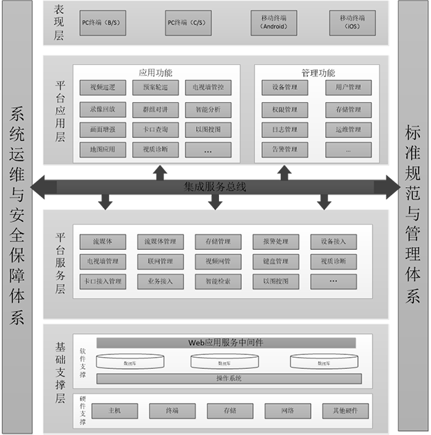
平台逻辑架构:

业务架构:
1.视频基础应用功能,包括图像资源调用、图像检索、大屏管控、报警接受等。
2.多媒体交互应用,实现移动终端间、PC终端间、移动终端与PC终端间的文字、语音和视频通讯。
3.视频运维管理,实时监测视频监控系统的运行状态,实现视频资源全面监控与集中统一管理。
4.地图应用模块,实现视频数据的时空关系分析和可视化应用。
5.提供丰富的应用终端,包括PC端的BS和CS客户端以及移动客户端,以具备可扩展性的框架提供实用的视频应用工具。
6.提供简易卡口,主要应用于简单场景下的卡口过车查询,以及布控应用。
7.提供社区应用模块,包含人员管理、房屋管理、出入查询、流动人口库的对接。
8.提供人员布控,支持对人员进行黑名单布控,同时支持布控告警。当前支持对人员刷卡进行布控。
9.提供人证应用模块,集成人证核验、人脸识别,实现人证统一信息采集、查询、比对、布控的应用分析系统。
10.提供报警流转,该系统的主要功能是需要进行报警的流转。在村、乡镇、县三级进行流转。
系统功能:
1.资源整合:公安、交通、金融、环保、教育、安监、城管、网吧、旅馆、沿街商铺、沿街企事业单位等视频资源。
2.视频巡防:视频巡逻、视频追踪、视频N+1、智能围堵(电子围栏)。
3.资源共享:政府多职能部门之间的公共安全共享应用。
4.重点人群管理:对重点人群采取各种措施,及时跟踪掌控其基本情况。
5.实有人口管理:采用“一人一档”管理机制,摸清村(社区)流动人口底数,实现信息“实时采集、及时更新”。
6.群防群治应用:机顶盒视频点播、群防群治APP、一键紧急报警。
上一篇: 没有了!
下一篇: 没有了!

青岛浩海网络科技股份有限公司
股票代码:430695
- 0532-87920299
- 0532-87920299
- haohai@ehaohai.com
- www.ehaohai.com
- 经营地址:青岛市市北区人工智能产业集聚区4号楼
技术支持: 青岛网站建设


